
The UK could see a 545-mile wall of snow and rain batter its large parts of the country with the risk of chaotic weather conditions returning for millions of people.
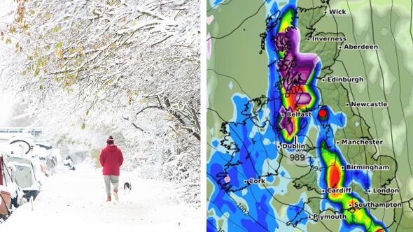
On March 15, the west coast of Scotland could see heavy snow, stretching as far inland as Glasgow, according to the latest weather maps from WXCharts.
Meanwhile, further south, heavy rain may blast the north-west of England, Wales, parts of the Midlands, the south-west and the south coast.
Eastern areas are expected to remain dry, although Hertfordshire and Buckinghamshire may see some light showers.
WX Charts forecasts are done in advance of Met Office forecasts, and are subject to change.

More snow could hit large parts of the UK on March 16 (Image: WXCHARTS)

The heaviest of the conditions will be in the western half of the UK (Image: WX Charts)
Without predicting specific conditions in different areas of the UK, the Met Office shares a similar outlook for middle of March. However, it does not predict any snow.
Its long-range forecast said: “The middle of March is most-likely going to be quite changeable and unsettled with spells of rain and strong winds in most areas, especially the north and west, with rainfall amounts probably above average.
“Some drier interludes are also likely between time though, especially in the south and east, and temperatures on the whole will be a little above average.”
The BBC’s long-range forecast for March 10-17 warns that although the period might start off dry and calm, that could soon change.

The wind could kick up over the weekend of March 15 (Image: WX Charts)
It says: “With an area of high pressure sitting near or over parts of the UK, conditions could remain dry and calm overall, at least at first.
“There is still a risk of wetter and especially windier weather, particularly in Scotland and Northern Ireland.
“However, the frontal zone remains erratic and undulating, so its southern extent is uncertain and subject to certain fluctuations. Given this the changeable conditions could spread to much of the UK during this week.
“It should remain fairly mild across the board and there continues to be little to no risk of any colder weather before the middle of the month.”