Nearly all English counties face snow on January 27, with the West Midlands expecting 18 hours of snowfall, but Cornwall and Hampshire are set to escape.
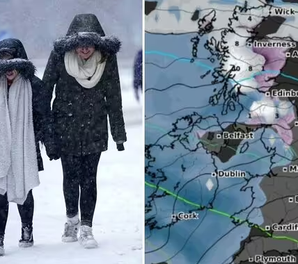
UK weather maps have shown that a 388-mile ‘wall of snow’ is poised to blanket dozens of counties next week.
The wintry conditions are forecast to arrive on Tuesday, January 27, with weather maps from WX Charts turning white.
The mass of snow is expected to reach the South West of England and parts of Wales at 6am before travelling eastwards, according to wxcharts.com.
Almost all English counties are set to see snowfall that day.

a (Image: undefined)
However, two southern counties, namely Cornwall and Hampshire, are expected to escape a covering.
Meanwhile, the West Midlands region is set to be beneath the blanket of snow by 12pm on Tuesday, with the snow persisting until 6am the following day on Wednesday, January 28 – a total of 18 hours.
It comes as the Met Office has issued warnings of colder conditions in the latter part of January.

a (Image: WX Charts)
In its long-range forecast from January 25 to February 3, the Met Office said: “Weather systems moving in from the Atlantic will continue to attempt to push in from the west, but tending to stall in the vicinity of the UK as they encounter high pressure to the north and northeast.
“As a result, further spells of rain or showers are likely at times.
“These may be heavy and persistent, especially in the south and west, with the best of any drier interludes in the far north and northeast.
“Whilst mild conditions are expected to encroach into the south and southwest at times, it is likely to turn somewhat colder through this period, bringing the risk of some snow showers, most likely across hills in Scotland and northern England.”