“Journey Through Time: Rare Photographs of Expeditions to Mesoamerica and South America in the 19th and 20th Centuries”
 In the late 1800s and early 1900s, adventurers plunged deep into the wilds of South and Central America.
What they found amidst the lush jungles were more than just plants and animals; they stumbled upon ancient ruins, hidden beneath the dense foliage.
These discoveries opened a window into the rich histories of the peoples who once thrived in these lands.
Back in the 19th century, whispers began to circulate about the existence of ancient cities lying hidden within the jungles of Mesoamerica and South America.
Long before Europe even knew the New World existed, the Maya had already built spectacular cities in these regions.
But as these civilizations declined, the jungle slowly engulfed their once-great cities. When the Inca Empire fell in Peru, the iconic Machu Picchu also faded into obscurity.

A monument known as Zoomorph P, located in Quiriguá, Guatemala. The carving represents the Cosmic Monster in Maya mythology.
It was during this time that explorers really started uncovering these archaeological marvels, treasures once believed to be lost forever.
Many Indigenous peoples in these regions knew of these hidden sites, scattered across the Yucatán Peninsula, Central America, and South America.
he tales from these early explorations inspired countless others to follow in their footsteps.
Artists’ drawings of the jungle ruins were particularly influential, encouraging later adventurers to bring along their cameras and capture these wonders in photographs, preserving them for future generations.

Copan. West Side of Doorway Leading to the Inner Chamber of Temple, 1885.
The Explorations of John Lloyd Stephens and Frederick Catherwood
In 1839, U.S. President Martin Van Buren appointed John Lloyd Stephens as the American Ambassador to Central America.
Soon after, Stephens embarked on a journey to explore the ancient Maya ruins in the region, accompanied by the English archaeologist Frederick Catherwood.
Stephens was primarily interested in exploring the ancient ruin of Copan and then moving on to Palenque. At this time, many of the now-famous Maya sites were unknown even to the indigenous people of the region.
The centuries had slowly covered the great temples and pyramids and turned them into mounds of green hills.
Only a few cities of the Maya were known to exist at this time, among them Copan, Palenque, Topoxte/Tayasal and the mysterious unnamed city deep in the jungle (which came to be known as Tikal).
There were no accurate maps of the region and the two men often discovered sites through word of mouth in conversation.

Copan. Stela A, South Side, 1885.
In his Incidents of Travel in Central America, Chiapas and Yucatan, Stephens writes of his first impressions of Copan:
Diverging from the base, and working our way through the thick woods, we came upon a square stone column, about 14 feet high and three feet on each side, sculptured in very bold relief, and all four sides, from the base to the top.
The front was the figure of a man curiously and richly dressed, and the face, evidently a portrait, solemn, stern, and well fitted to excite terror.
The back was of a different design, unlike anything we had ever seen before, and the sides were covered with hieroglyphics.
This our guide called an `Idol’ and before it, at a distance of three feet, was a large block of stone, also sculptured with figures and emblematical devices, which he called an altar.
The sight of this unexpected monument put at rest at once and forever, in our minds, all uncertainty in regard to the character of American antiquities, and gave us the assurance that the objects we were in search of were interesting.
Not only as the remains of an unknown people, but as works of art, proving, like newly discovered historical records, that the people who once occupied the Continent of America were not savages.

Copan. Stela C, East Face and Altar, 1885.
The Explorations of Alfred Maudslay
Alfred Percival Maudslay, a British colonial administrator and archaeologist, undertook a significant expedition in 1881.
As an explorer, Maudslay ventured into the jungles of Central America in search of Maya sites. His initial efforts were met with challenges, as he grappled with the dense jungle terrain in his quest to locate ancient ruins.
He started at the Maya ruins of Quirigua and Copan where, with the help of Frank Sarg, he hired laborers to help clear and survey the remaining structures and artifacts.
Sarg also introduced Maudslay to the newly found ruins in Tikal and to reliable guide Gorgonio López. Maudslay was the first to describe the site of Yaxchilán.

Copan. Stela H., 1885.
With Teobert Maler, Alfred Maudslay explored Chichén in the 1880s and both spent several weeks at the site and took extensive photographs.
Maudslay published the first long-form description of Chichen Itza in his book, Biologia Centrali-Americana.
In the course of his surveys, Maudslay pioneered many of the later archaeological techniques. He hired Italian expert Lorenzo Giuntini and technicians to make plaster casts of the carvings, while Gorgonio López made casts of papier-mâché.
Artist Annie Hunter drew impressions of the casts before they were shipped to museums in England and the United States.
Maudslay also took numerous detailed photographs – dry plate photography was then a new technique – and made copies of the inscriptions.

Quiriguá. The Great Turtle P, The South Face and East Side, 1883.
Machu Picchu: Search for the Inca capital
In 1911, American historian and explorer Hiram Bingham journeyed through the region in search of the old Inca capital. He was guided to Machu Picchu by a villager named Melchor Arteaga.
During his exploration, Bingham came across the name “Agustín Lizárraga” and the date “1902” inscribed in charcoal on one of the walls of the Temple of the Three Windows.
Initially feeling disappointed, he recorded in his pocket field journal: “Agustín Lizárraga is the discoverer of Machu Picchu and lives at San Miguel Bridge just before passing.”

The ancient Maya ruins of Palenque, found in modern-day Chiapas state, Mexico. This photo was taken by British explorer Alfred Maudslay, circa 1880s-1890s.
While Bingham initially credited Lizárraga as the discoverer in his early writings and speeches, such as in “Inca Land” (1922), he gradually diminished Lizárraga’s role.
In the final version of his story, “Lost City of the Incas” (1952), Bingham claimed to have found the site himself.
Although Bingham was not the first to visit the ruins, he was considered the scientific discoverer who brought Machu Picchu to international attention.
He organized another expedition in 1912 to conduct extensive clearing and excavation work at the site.

In the modern-day Yucatán state of Mexico, the ancient Maya city of Chichén Itzá was largely reclaimed by the jungle for years until excavations began to remove the vegetation in the 19th century.
Machu Picchu was built in the classical Inca style, with polished dry-stone walls.
Its three primary structures are the Temple of the Sun, the Temple of the Three Windows, and the Intihuatana.
Most of the outlying buildings have been reconstructed in order to give visitors a better idea of how they originally appeared. By 1976, 30 percent of Machu Picchu had been restored and restoration continues.

The Maya Palace of Palenque, circa 1880s-1890s.

Temple B at Tikal, as seen during the visit of British explorer Alfred Maudslay to this ancient Maya site in Guatemala, circa 1880s-1890s.

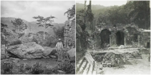
Monuments sitting in a field in the ancient Maya civilization of Copán, modern-day Honduras.

Two children sit at the edge of a chamber in Copán, Honduras, where numerous statue heads (and one torso) are lined up on a wall.

A Honduran man stands next to a massive stela in Copán. Circa 1880s.

Canadian archaeologist George Gordon standing beside the Hieroglyphic Stairway in Copán, 1900s.

The Palace at Palenque, showing House B and House C.

The Temple of the Inscriptions, located in Palenque, and photographed in 1890.

A tall monolith, known as Stela D, stands in Quiriguá, a Maya site in Guatemala. This ancient stone monument, dating back to 766 C.E., was captured in a photograph during one of Alfred Maudslay’s expeditions.

In the 1890s, Anne Maudslay, wife of Alfred Maudslay, gazes upon the ruins of Quiriguá, Guatemala.

During one of Alfred Maudslay’s expeditions, his team posed by the Palace at Palenque to provide a sense of its size.

A leaning stela at Quiriguá in Guatemala.

A 1912 photograph captures Machu Picchu, a 15th-century Inca citadel in Peru, taken during Yale professor Hiram Bingham III’s expedition.

An 1885 photograph captures a Maya stela in Copán, situated in present-day Honduras.

Photograph of Alfred Maudslay at Chichén Itzá, 1900.

Maudslay captured this image of Chichén Itzá’s Casa de Monjas by standing on the roof of another structure.

A 780 C.E. monument known as Zoomorph B in Quiriguá, Guatemala. Photographed circa 1880s.

The east side of a monument known as Stela D, which dates to 766 C.E. Alfred Maudslay took this photograph in Quiriguá in the 1880s.

A monolith tilting on its base, photographed by Maudslay in Copán, Honduras.

People stand in the doorway of Casa de Monjas at Chichén Itzá.

The Great Ball Court at Chichén Itzá.

The Palace at Palenque, 1900.

The condition of this tower at Palenque highlights the challenges that archaeologists faced in the late 19th and early 20th centuries. Tree roots intertwined with long-abandoned structures made it extremely challenging to preserve these ancient ruins.

The stairs at the Temple of Kukulcan in Chichén Itzá.

A monument known as Stela D in Quiriguá, Guatemala. This structure is believed to depict K’ak’ Tiliw Chan Yopaat, an eighth-century Maya ruler.

The Temple of the Sun in Palenque, Mexico.

A monolith in Quiriguá, Guatemala tilts precariously in this 1894 photograph.

The ancient ruins of Palenque, Mexico, 1900.

Quiriguá. The Great Turtle P, The South Face and East Side, 1883.A Peruvian farmer named Melchor Arteaga, pictured crossing the Urubamba River near Machu Picchu in 1911. Arteaga was one of the local people who helped guide Bingham to the historic site.
(Photo credit: The British Museum / Pitt Rivers Museum / Library of Congress / Wikimedia Commons).