Parts of the UK will sizzle in a mini-heatwave with highs of 26C this week.
UK weather map shows warming temperatures
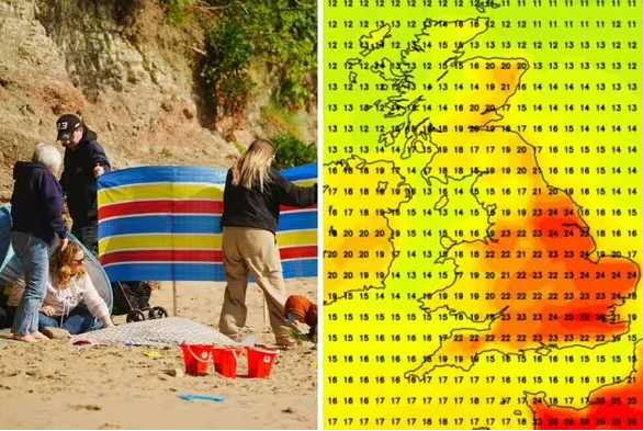
A mini-heatwave is set to bring high temperatures across a stretch of the UK this week, with the mercury climbing to 26C in some areas, according to new weather maps. Forecasts from Net Weather show a wave of hot and sunny weather rolling across the country on Friday, May 30, setting in for a 48-hour burst of heat before cooling off for a few days ahead of a resurgence the following Tuesday. Southeastern regions will see the steepest climb in temperatures, with areas around London, Kent and Essex soaring to 26C by 6pm on May 30, as a Caribbean jet stream takes hold.
North Yorkshire and parts of the East and West Midlands could also see highs of 24C on Friday and Saturday, with eastern coastal areas including Lincolnshire and the Humber set to roast at the end of the week. The hot spell will largely hold on Saturday, May 31, forecasts suggest, with London, Essex and parts of the southeast hovering around 26C by the early evening.
DON’T MISS
Powered by
UK weather maps show England and Scotland battered by snow and rain storm
The mini-heatwave will hit southern parts of the UK on Friday (Image: NetWeather/PA)
Parts of England will reach 26C on Friday (Image: NetWeather)
The burst of hot weather will be ushered in by a Caribbean jet stream (Image: NetWeather)
The mini-heatwave will hold until Saturday evening (Image: NetWeather)
We use your sign-up to provide content in ways you’ve consented to and to improve our understanding of you. This may include adverts from us and 3rd parties based on our understanding. You can unsubscribe at any time. Read our Privacy Policy
While temperatures are likely to hover around a lower seasonal average over the first few days of next month, they will return to around 25C in southern England on Tuesday, June 3, according to forecasts.
Once again, the wave of hot weather is expected to be concentrated around London and Kent, with cooler predictions for the rest of the UK – which will see the mercury hover around 17C in Scotland and northern England, rising slightly to 20C in Cornwall and Devon.
The Met Office‘s long-range forecast for May 30 to June 8 also predicts “very warm, perhaps hot conditions developing”, especially in southern regions – although it has also warned of accompanying thunderstorms.
After cooling off for a few days, temperatures will soar back up to the mid-20s on June 3 (Image: NetWeather)
The Met Office’s five-day weather forecast:
Today:
Generally sunny, with occasional showers and some thunder possible in the north. Rainfall also expected to move across western England throughout the afternoon.
Tonight:
Rain and wind moving eastwards overnight, followed by clear spells in the north, with drizzle and a strong breeze likely to remain into the morning.
Tuesday:
Rain and wind forecast across most of Britain and Northern Ireland, with slightly sunnier conditions and rain showers in Scotland.
Outlook for Wednesday to Friday:
Temperatures expected to remain around the seasonal average, with intermittent showers, periods of settled sunshine and wind.