A blanket of the white stuff is heading for the country and new maps show which areas will be hardest hit.

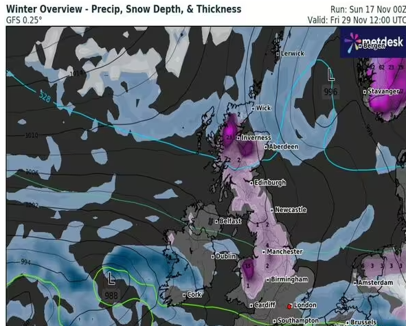
The UK can expect snowy conditions to arrive in by the end of the month (Image: WxCharts)
An Arctic blast of cold winter weather is set to bombard Britain in the coming days with as much as 20cm of snow settling in some regions.
The wintry wipeout has been spotted on new forecast maps from weather watchers WXCharts for Friday November 29 and Saturday November 30.
As these maps show, parts of the Scottish Highlands could see nearly eight inches of snow north of Inverness and in England Cumbria and Northumberland will also get a heavy dusting.
Over 24 hours it looks like the blizzard-like conditions will also break out across high ground further south in England across the Pennines and the Midlands.
Almost all of Wales also looks likely to get wintry conditions with snow falling from Snowdonia in the north to Cardiff in the south.

Snow is expected to blanket large parts of the country on November 29 (Image: WXCharts )
According to a long-range Met Office forecast “cold” to “very cold” temperatures are expected from November 21 to November 30.
A statement from the weather agency said: “Cold or very cold conditions are expected across most if not all parts of the UK early in this period, with wintry showers affecting in particular northern parts and exposed coastal districts, although it may well be largely sunny inland.
“Overnight frost will be widespread and occasionally strong winds will result in significant wind chill.
“However, there is an increasing chance through the first weekend and into the following week of more organised areas of rain, snow and strong winds affecting many areas, this probably also associated with milder temperatures, at least in the south.

Forecast maps show wintry conditions lingering over 48 hours (Image: WXCharts )
“Later in the period, conditions remain uncertain, but it is most likely to remain mostly unsettled with further spells of rain and snow.”
Into December the Met Office added that there was “a trend towards drier and more settled conditions, with high pressure potentially being the more dominant influence over the UK”.
Met Office five-day forecast
Today:
Further blustery wintry showers for northern Scotland. Driest and brightest towards the south. Feeling colder. Hazy spells of sunshine will be replaced by cloud and patchy rain across northern and western parts.
Tonight:
Unsettled across central areas with outbreaks of rain, heaviest in the west. Scattered wintry blustery showers in the far north, with clear spells leading to a cold and frosty night.
Monday:
Hazy sunshine in the north and east with wintry showers in the far north. Spells of heavy rain elsewhere, turning to snow, mainly over the high ground in the north.
Outlook for Tuesday to Thursday:
An unsettled start on Tuesday with rain and possible snow, clearing to sunnier spells. Frosty mornings on Wednesday and Thursday but drier with a few wintry showers. Colder and windier.


