Northern parts of the country are likely to experience cold weather conditions as temperatures begin to drop, maps suggest.

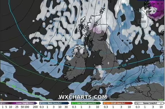
UK weather maps show half of Britain “surrounded” by snow (Image: WXCharts)
Parts of Britain are likely to witness cold weather conditions as the latest weather maps have turned purple indicating Britain is facing a deluge of snow in weeks. Maps from WXCharts show that half of the country is surrounded by snow as the temperature level plunges to zero.
The freezing conditions are likely to hit the country on November 7. Areas around Scotland are likely to be worst affected by the snowy conditions.
It comes days after Storm Ashley caused substantial travel disruption throughout Britain, with London flights delayed while, in Scotland, average wind speeds hit 85mph over the weekend.
This week, speed restrictions have been put in place as high winds continue to batter Scotland, as flights still face delays across major airports in the region.
But according to WXCharts maps, by early November, areas such as Wick, Inverness, and Aberdeen are likely to experience 1-2cm of snow per hour.

Weather maps have turned purple indicating the possibility of snow. (Image: WXCharts)
The sudden change in the weather will also push the temperature downwards with most parts of the country shivering at 2-3C on November 7.
Jim Dale, a meteorologist with British Weather Services told Express.co.uk: “We may see a cold plunge after a lengthy period of dry and sedate weather. Snowy conditions are possible for the north and the Grampians. It looks like a straight arctic blast. However, it needs to be carefully observed as it is a long way from now.”
The Met Office’s long-range forecast between November 6 and 20 reads: “A change in the broad weather pattern over the UK is expected towards mid-November and beyond, as high pressure initially over the nearby continent tends to become more focused to the north or northwest of the UK.
“This may allow areas of low pressure, south-shifted from their more typical tracks, to approach southern UK and bring rain or showers at times.
“As a result, after a relatively dry start to the month in the south and east it is likely to become wetter than average here, while conversely northwestern areas, after a wetter start to the month, will tend to revert to drier than average conditions.
“Temperatures will probably be close to average for much of this period as a whole, although some colder interludes are possible.”

Temperature levels are likely to plunge to 1C during that period, maps show. (Image: WXCharts)
The five-day forecast by the Met Office suggests low cloud and fog over England and Wales will lift, leaving many areas dry with bright or sunny spells, though a few showers may develop. In the far north and west of Scotland, thicker cloud will bring patchy rain, accompanied by windy conditions.
Tonight will be mostly dry with clear spells, although cloud cover will increase in the north and west, bringing some patchy rain to the northwest. It will remain mild but increasingly windy, with gales expected in the far northwest.
On Thursday, central and eastern areas will stay dry with bright or sunny intervals, while the north and west will see cloudier skies, strong winds, and patchy rain, which will become heavier in the far west later in the day.
Looking ahead to Friday through Sunday, conditions will become more unsettled, with rain affecting most areas at times, occasionally heavy. It will often be windy, with the possibility of gales in exposed regions, while temperatures will generally be around normal for the season.


