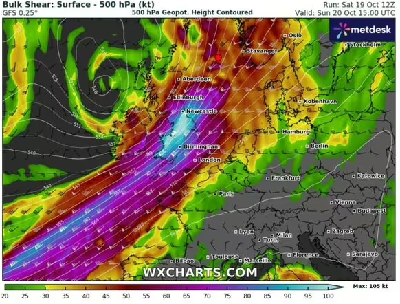
Storm Ashley is set to come barrelling across to Britain, with the Met Office issuing a danger to life warning for some regions.
Millions of Brits are braced for chaos in hours as the eye of Storm Ashley centres over parts of Britain, unleashing 80mph winds. It is the first named storm of the season, and it’s set to come crashing over Britain abruptly in a matter of hours.
The deep-low pressure system, funnelling up through the Atlantic, was named by Met Eireann, the Irish Met Office, as its strongest point is set to be when it arches over Northern Ireland tomorrow (October 20).
But that’s not to say the rest of Britain will remain unaffected. The Met Office has issued a rare amber weather warning for wind, covering parts of Scotland. A much larger yellow weather warning, spanning a vast area, will run concurrently.
Those covered by the amber warning have a good chance of power cuts, with mobile phone signal also likely to cease. There’s a likelihood of damage to buildings, disruption to public transport and roads, road closures and a danger to life risk.
Ashley is set to arrive with a bang, with the Joint Cyclone Center predicting the storm will “upgrade” to a category three cyclone on the south west approach tonight, before downgrading once again as the impacts are felt.

Storm Ashley’s true colours have been depicted in this incredible map (Image: WXCHARTS)
Full list of regions under an amber weather warning
The amber warning comes into force from 9am until just before midnight tomorrow.
Highlands & Eilean Siar
- Na h-Eileanan Siar
- Highland
Strathclyde
- Argyll and Bute

Red markers show the intense winds smashing across the nations (Image: Netweather)
Full list of areas covered by the yellow weather warning
Central, Tayside & Fife
- Angus
- Clackmannanshire
- Dundee
- Falkirk
- Fife
- Perth and Kinross
- Stirling
Grampian
- Aberdeen
- Aberdeenshire
- Moray
Highlands & Eilean Siar
- Na h-Eileanan Siar
- Highland
North West England
- Cumbria
Northern Ireland
- County Antrim
- County Armagh
- County Down
- County Fermanagh
- County Londonderry
- County Tyrone
Orkney & Shetland
- Orkney Islands
- Shetland Islands
SW Scotland, Lothian Borders
- Dumfries and Galloway
- East Lothian
- Edinburgh
- Midlothian Council
- Scottish Borders
- West Lothian
Strathclyde
- Argyll and Bute
- East Ayrshire
- East Dunbartonshire
- East Renfrewshire
- Glasgow
- Inverclyde
- North Ayrshire
- North Lanarkshire
- Renfrewshire
- South Ayrshire
- South Lanarkshire
- West Dunbartonshire
Wales
- Ceredigion
- Conwy
- Gwynedd
- Isle of Anglesey
- Pembrokeshire

The jetstream shows a white hue at the centre, indicating the severity of the storm (Image: Netweather)
While an amber warning is in place, Jim Dale, a senior meteorologist for British Weather Services, claimed there is a 20 percent risk of a red warning being issued.
Speaking to Express.co.uk, he said: “It already is expected to be a type of ‘cyclone’ in terms of it being a named storm, with a 954mb centre as it moves towards us from the Atlantic later tonight. Cyclones per se usually refer to storms in the Indian Ocean & Coral Sea, akin to a typhoon or hurricane in other parts of the globe, so this is simply a play on words rather than a classic tropical based cyclone.
“Still, with wind gusts expected of circa 80mph in the amber zone and with spring tides running high it will be an event with some acute dangers within.
“But principally for northern parts of the UK and western Wales. If there is to be any upgrades then it will be in terms of the amber warning turning into red but I have that as only a 20% chance right now.”


