UK weather maps turn volcanic red and show when new heat blast drags temperatures to 38C.uk
Weather maps indicate the UK is set to scorch under a 38C heat blast.

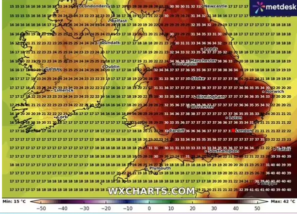
UK weather maps have turned a volcanic red (Image: WXCharts)
Sweltering 38C weather looks set to scorch the UK as the latest weather maps show the exact date when the blistering heat will blast the country. WXCharts maps have turned a volcanic red, indicating that the UK is set to sizzle.
Temperatures hit 33.2C in Charlwood, Surrey, on Saturday as the country sweltered under an amber heat-health alert. And if forecasts hold true, the UK could face another wave of intense heat on Wednesday July 9, with temperatures potentially even further to 38C. Weather maps indicate that the entire country will bask in balmy weather with the West Midlands likely to see the hottest temperatures.

By Midday temperatures across the country will already be 35C-plus (Image: WXCharts)
At Midday on July 9, the mercury in London, Surrey, and Kent will have already soared to a sizzling 36C.
The East of England will not be far behind with temperatures predicted to hit 35C.
Meanwhile, key UK cities including Cardiff, Birmingham, and Manchester will see temperatures rocket to 30C above.
The mercury looks set to only soar higher as we go into the day. By 6pm Coventry and Worcester in the West Midlands will see temperatures climb to a scorching 38C.
London, Surrey and Kent are predicted to be a degree cooler. The entirety of the south east East Midlands will be covered by a wall of 35C-plus heat.
Bristol, Liverpool and Manchester are all forecast 36C heat whilst Cardiff will see slightly cooler conditions of around 30C. Parts of the south west will see the coolest temperatures of around 25C.
Separately, the Met Office‘s weather outlook for this period states that “conditions will likely continue to be changeable through much of July” and “southern and eastern areas are most favoured for longer drier and more settled spells, although even here some occasional rain or showers will be possible, perhaps thundery”.
However, temperatures are expected to be “above average for most areas, especially towards the southeast where there will be an ongoing chance of some very warm or hot conditions at times”.