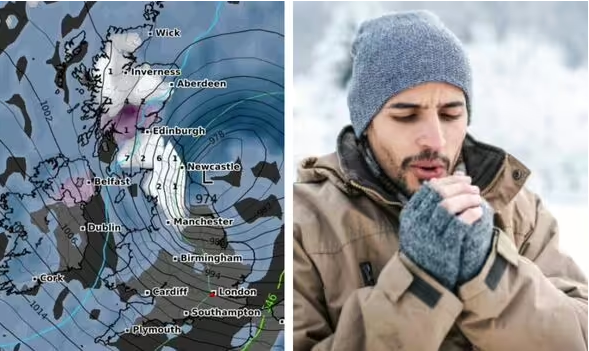
A shocking new map shows regions across the UK being covered by a white blob of incoming snow.

New weather maps suggest major battering of snow could be just days away. (Image: wxcharts.com)
Millions of Britons are set to be pelted with snow in just days, new maps suggest, with half of Great Britain freezing in 0C temperatures.
According to the latest forecast data from WXCHARTS.COM, large swathes of the country are expected to see snowfall on Saturday, December 7, at 3am, with northern England and Scotland the worst hit.
A precipitation, snow depth and thickness forecast for that day shows a huge blob of white hanging over most of Scotland, including Edinburgh, with 1-7cms of snow falling per hour in the early hours. Central and southwestern areas are predicted to be the worst hit.
Large areas of northern England from the border regions down as far as Manchester are also expected to see snowfall, with between 1-2cm of flakes falling per hour, the maps suggest.
Sterling and Greenock are among cities and towns that could see snow depth of around 1cm.
The same applies to areas of Northern Ireland, including the capital, Belfast with rain elsewhere in Northern Ireland.

Map showing precipitation, snow depth and thickness on December 7. (Image: wxcharts.com)

Multiple areas of the UK, including most of Scotland, is expected to see snow. (Image: wxcharts.com)
Meanwhile, rain is also anticipated for much of the UK.
Areas around Manchester down through the Midlands will see showers, as will the northeastern, east, and the southwest of England.
Much of Wales is also in for a drenching according to the charts.
A separate chart shows minimum temperatures of 0C for most of Scotland and areas close to the border between the two nations, including Newcastle.
Towards the south of the British Isles, it’s not expected to get quite as cold, though mimimum temps may only be in the low to mid single digits.

Minimum temperatures map (Image: wxcharts.com)
The Met Office‘s three-five day forecast for Thursday to Saturday doesn’t mention snow, but warns conditions will turn “more unsettled in the coming days with heavy rain and strong winds at times, particularly into the weekend with gales possible.
“After a mild few days, turning colder later,” the government agency adds on its website.
Meanwhile, the national weather agency has issued several yellow weather warnings as temperatures are expected to drop in the next few days.
The Met Office issued a yellow alert for ice in Scotland from 9pm tonight to 10am tomorrow, warning of potential disruption and the risk of crashes.
The Met Office says, “A band of rain and snow will move east across Scotland this afternoon and evening (which could lead to some lying snow on higher transport routes).
“Once this clears temperatures will quickly fall during Tuesday evening and ice is likely to form readily on untreated surface during the evening and overnight into Wednesday morning.”
Areas affected include a couple of dozen local authorities in Central, Tayside & Fife, Grampian, Highlands & Eilean Siar, SW Scotland, Lothian Borders, and Strathclyde.
Yellow warnings for wind and ice are also in effect on Wednesday and Thursday. You can find the latest warnings, advice and areas affected here.


