The Met Office has issued nearly two full days worth of weather warnings, with five parts of the UK currently affected by the latest yellow alerts.
The Met Office has slapped an extra 43 hours of snow warnings over five regions of the UK – and it’s set to fall within hours.
Experts at the national forecaster have issued a yellow alert for Northern Ireland, Grampian, Central, Tayside & Fife, Orkney & Shetland, as well as Highlands & Eilean Siar.
The weather warnings start at 3pm today (Monday, November 18) and last until 10am on Wednesday, November 20.
This is in addition to a huge yellow warning for snow and ice covering most of the north of England, stretching from the Scotland-England border down to north Wales and Nottingham, in place from 7pm today until 10am tomorrow.
It comes as experts at the Met Office have predicted potential travel disruption as a result of the snow and ice, with up to 20cm of snowfall expected as an Arctic blast swirls over Britain.

A Met Office map shows a huge chunk of the UK has been hit by weather warnings for snow and ice (Image: Met Office)

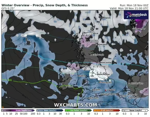
WX Charts’ maps show snow falling today in England, Scotland and Northern Ireland (Image: WX Charts)
In its warning, they said that pavements that aren’t gritted, as well as some cycle paths will become “impassable”, while there is also a small chance of power cuts, with mobile phone coverage likely affected in parts.
They added that “there is a slight chance that some rural communities could become cut off” by the snow and ice, while Brits are being warned of potential injuries occurring thanks to slips and falls on icy sufaces.
It said: “There is a small chance of travel delays on roads with some stranded vehicles and passengers, along with delayed or cancelled rail and air travel.”
Meanwhile, 13 English cities are preparing for power cuts as a result of a 15-hour snowstorm over the next day, with Manchester, Liverpool, Newcastle, Leeds, Sheffield, Nottingham, Stoke, Chester, Lincoln, Derby, York, Durham and Hull all affected.
The Met Office warning continues: “Snow and hail showers will affect northern parts of Scotland at times, becoming heavier and more frequent on Monday night, through much of Tuesday and then overnight into Wednesday morning.
“2 to 5 cm of snow is likely to accumulate quite widely, with up to 10 cm in some places by the end of Tuesday, and perhaps 15 to 20 cm accumulating above 300 metres.
“Showers may be sleety at times along north-facing coasts, although icy surfaces are likely at times.”
The Met Office also revealed that last night was the coldest of the season so far, with temperatures plummeting to minus 7.8C in Tulloch Bridge in the Scottish Highlands, despite mild temperatures of up to 12.5C in the South West of England.


