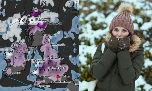
Forecast data collected by wxcharts.com suggests widespread snow could be on the way next week too, with major cities including Birmingham and Manchester potentially in for a pasting.

Temperatures are expected to plummet across the country next week. (Image: wxcharts / Getty)
Millions of people across the UK are bracing for bitterly cold weather next week as freezing Arctic air sweeps in, with weather maps showing which towns and cities are expected to be pounded with snow.
The Met Office shared a post on X showing temperatures quickly falling over the coming days, suggesting millions of Brits could see a precipitous plunge in temperatures at the start of the week.
Vast swathes of the British Isles are expected to see the mercury drop -9C below the maximum average temperature for this month by Tuesday (November 19), the map suggested.
Forecast data collected by WXCharts.com suggests widespread snow could be on the way next week too, with major cities including Birmingham and Manchester potentially in for a pasting.
Read on to find out whether your area could be affected.

New weather maps show snow falling across Britain next week. (Image: wxcharts.com)

Major cities like Birmingham and Manchester could be blanketed in snow. (Image: wxcharts.com)
London
London looks to be drenched with what appears to be upwards of 1mm of rain per hour on Monday, November 18, with snow depth of around 1cm by the following day.
Maps showing snow depth on Thursday, November 21 suggest it may have receded from the capital by then, though thick mounds of snow will remain northwards throughout the Midlands up to Scotland.
Manchester
WXCharts’ maps showing the outlook at 6pm on Monday, suggesting areas around Manchester could be bucketed with 2cm of snow as an ominous white blob covers northern areas down through the Midlands.
Maps showing snow depth of the days that follow suggesting it could be between six and seven inches by Thursday.

Snow will remain on the ground amid the freezing temperatures, according to the latest forecasts. (Image: wxcharts.com)

Scotland and Wales are also set for some very heavy snowfall. (Image: wxcharts.com)
Birmingham
Snow amounting to 1cm or more looks set to blanket Birmingham and surrounding areas on Monday evening, as flakes fall across much of the country next week.
The Midlands city is then expected to see snow depths of around 1cm for the next few days up to Thursday.
Liverpool
Liverpool looks to be in line for similar amounts of snow as Manchester on Monday (around 2cm), with indications the North West city may face rain the following day.
Snow depth maps suggest Liverpool may see smaller amounts of snow on the ground (between 1cm and 2cm) than other parts of the country, persisting into Thursday.
Cardiff
Wales looks set to be among the worst hit by snow, according to the maps, with around 3cm per hour on Monday, rising steeply to depths of 18cm on Tuesday, and 20cm on Wednesday.
Charts suggest communities in the north of the country could see snow depth as high as 20cm through to Thursday.
The capital Cardiff, looks set for rain on Monday and less intense snowfall totals between 2 and 4cm by Thursday.

Map showing precipitation, snowdepth and thickness on Thursday next week. (Image: wxcharts.com)
Glasgow
Parts of Scotland are also expected to see heavy snow, with the Highlands starting off the week with areas of 1 and 2cm of snowfall and 9 inches of snow depth before being hammered by 28cm of snow by Thursday in some areas.
Snow depths in the northern Highlands up towards the coast are forecast to be 16cm that day, as a wall of white covers the top half of the country towards the end of next week.
Current maps suggest Glasgow and Edinburgh may be among the few areas of the country not in the path of the snow and rain looming over next week.
The Met office‘s long-range forecast for November 19-28 predicts cold or very cold conditions “are likely to affect most if not all parts of the UK early in this period, with wintry showers affecting in particular northern parts and exposed coastal districts”.
“Overnight frost will likely be widespread and occasionally strong winds will result in significant wind chill,” it continues, “However, there may be more organised areas of rain and snow, accompanied by strong winds, which run across some parts.
“This could lead to some disruptive weather at times, especially at the start of this period. Briefly milder conditions may accompany these in the south.
“There is a hint that it may become less cold late in the period, but still likely remain mostly unsettled with further spells of rain and snow,” it adds.
You can find the latest Met Office forecasts and weather warnings here.


